River otters, Rocky Mountain elk, mule deer, Rocky Mountain bighorn sheep, beavers, Bald Eagles, Magpies, and Brown Trout in the Flaming Gorge National Recreation area.
The OHV riding opportunities in Flaming Gorge Country are some of the most diverse in the country! You can choose to ride along the trophy fishing waters of Lake Flaming Gorge, roam the wildlife-rich sagebrush plains & canyons of Wyoming's high desert or head to the high alpine country of the Ashley National Forest. Of course, we suggest you stay around a little while and try them all.
Below you will find our ever expanding list of trails to enjoy, as well as important information on how to be legal in both Utah & Wyoming.
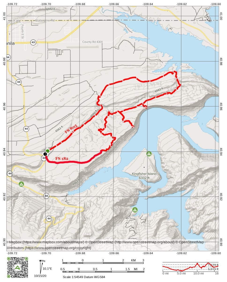
The trail starts just off HWY 44 at the Manila landfill turnoff 7-8 minutes south of town. You can ride the loop in either direction. Start on FS 182 or FS 805. Their are numerous side trails to explore, many leading up to the top of the Sheep Creek cliffs with incredible views. The trail between the lake and Finch's Cave gets muddy. The stretch between Finch's Cave and the Name Gap (the walls have numerous names carved into it) has some technical riding over picturesque Weber sandstone.

Riding on the Ashley National Forest:
OHVs are a great way to combine America’s love of motor vehicles with the love of the outdoors. To make your time in the outdoors safe as well as entertaining, you need to know the laws governing OHV use on public land. The cornerstone of any outdoor recreation activity is respect: respect for yourself; respect for others and respect for the environment.
The Ashley National Forest District travel maps show travel opportunities available for high clearance vehicles, ATVs, and motorcycles. Many areas and trails on the Forest are open to off-highway vehicles. The Ashley National Forest adopts States of Utah and Wyoming Off-highway vehicle regulations, with the basic direction that all "areas and routes are closed unless designated open.
Travel plan maps and motorized trail maps have the most accurate information regarding trails that are open to ATV's and motorized recreational vehicles. These maps are available at most Ranger District and Forest Service offices.
Riding on BLM Lands:
Most of the upper portions of Flaming Gorge National Recreation Area are surrounded by public lands managed by the Bureau of Land Management, Rock Springs, WY Field Office. One can explore scenic basins or the unique Killpecker Sand Dunes. South of the NRA, the Uintah Basin BLM lands offer popular open riding areas for riders of all abilities.
Click here to view the Top Ten BLM OHV Regulations
The Rock Springs Field Office manages more than 3.6 million acres of public land surface and 3.5 million acres of public subsurface minerals in the southwestern part of Wyoming. The field office administers a variety of programs including mineral exploration and development, wildlife habitat, outdoor recreation, wild horses, livestock grazing and historic trails.
For more information, please contact:
|
Rock Springs Field Office | 280 Highway 191 North | Rock Springs, WY 82901 |
|
Phone: 307-352-0256 | Fax: 307-352-0329 | Office hours: 7:45am - 4:30pm, M-F |
The Vernal Field Office is located in the northeast corner of Utah and administers lands within Daggett, Duchesne and Uintah Counties, plus a small portion of Grand County. The BLM also has Native American Trust responsibilities for Northern Ute Tribal and allotted mineral trust lands located within these counties. The area includes the south slope of the Uinta Mountains, the Uinta Basin, and the Book Cliffs region.
The management area is bounded on the west by the Wasatch Mountains and on the east by the Douglas Creek Arch in Colorado. There are approximately 7,325,500 acres within the boundary, of which 1,725,500 acres are BLM-managed surface lands. The Vernal Field Office administers energy related mineral activities on 3.8 million acres of Federal mineral lands (includes 1.3 million acres of National Forest Service lands) and post lease mineral operations on Indian trust mineral lands.
The VFO also offers a great variety of recreational activities; such as mountain biking, hiking, hunting and fishing. For more information, please contact:
Vernal Field Office | 170 South 500 East | Vernal, UT 84078
Phone: (435) 781-4400 | Fax: (435) 781-4410
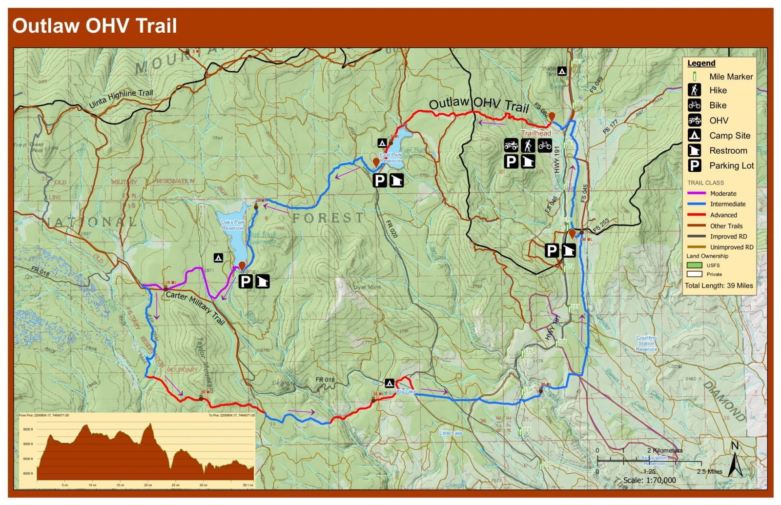
The Outlaw ATV trail runs through the beautiful Uinta Mountains. A portion of the trail runs parallel to the Flaming Gorge-Uintas National Scenic Byway. There are great views of the Uinta Mountains, canyons, lakes and many high-elevation grassy parks or meadows. Riding the entire trail is only recommended for riders with above average skills. Even though this trail is only 38 miles long it is an all-day ride. Portions of the trail are very challenging and most are very rocky. Allow a full day to cover the length of the trail.

Download the Outlaw ATV Trail brochure here.
The North Elk Park Trail is 9.0 miles long. It begins at Elk Park Trailhead and ends at Road 043. The trail is open for the following uses: Motorcycle Trail Riding, ATV Trail Riding, Off Highway Vehicles (OHV) less than or equal to 50 inches wide
The South Elk Park Trail is 3.6 miles long. It begins at Elk Park Trailhead and ends at Trail 1016. The trail is open for the following uses: Motorcycle Trail Riding, ATV Trail Riding, Off Highway Vehicles (OHV) less than or equal to 50 inches wide

The Swett Ranch trail is 6.0 miles long. It begins at the Greendale Overlook off UT Hwy 44. Descend from the Overlook on roads that encircle the historic Swett Ranch. This well preserved ranch offers a glimpse of local pioneer life, as well as tools used to work the land during the early 1900's. The Ranch is now maintained by the US Forest Service and is open to the public during the summer months. The trail is open for the following uses: Motorcycle Trail Riding, ATV Trail Riding, Off Highway Vehicles (OHV) less than or equal to 50 inches wide. This trail is open for use from May 1 to September 30, conditions permitting.

The Old Carter Military Trail is 6.7 miles long. It begins at Browne Lake Trailhead and ends at Road #059 At District Boundary. The trail is open for the following uses: Motorcycle Trail Riding, ATV Trail Riding, Off Highway Vehicles (OHV) less than or equal to 50 inches wide.

Get out and enjoy the newest ATV trail in Flaming Gorge! Completed in 2014, the Sheep Creek ATV Trail runs from Sheep Creek Lake through the forest to the newly renovated Summit Springs Guard Station. There are multiple trailhead parking opportunities along the route. The main trail (#166) is 6.77 miles long and is generally an easy trail with a few moderately difficult sections. This trail is designed for ATV's that are 50" or less in width. The trail can be combined with OHV riding along the Spirit Lake Scenic Backway, making for multiple day riding opportunities.

There are some great OHV Open Riding Opportunities in the Uintah Basin surrounding the town of Vernal. Take a look at the following:
The Leucite Hills are the remains of volcanic flows from these Pleistocene eruptions. The presence of the Leucite Hills created a gap through which the prevailing westerly winds funnel. These winds are strong enough to carry sand and gravel. As the winds blow through the eucite Hills, the sand collects in large sand dunes. These dunes can reach heights of over 100 feet and run for over 100 miles from west to east. The biggest dunes are in the Killpecker Dune Field, which begins several miles east of the town of Eden. The area around the Killpecker Dune Field is home to a herd of rare desert elk, found nowhere else in North America.
The rough and rocky terrain of the Leucite Hills, with its numerous springs of fresh water, was well suited to trapping and holding wild horses. The area became known as the Natural Corrals. Wild horses can still be seen in this area today. Thriving on the grasses of the Red Desert are descendants of horses brought to the New World by the Spanish in the 16th century.
Many recreationalists enjoy hiking in the area, as well as driving off-road vehicles. Signs are posted as to the specific locations where off-road vehicles can be used.
More Information:
Download the Killpecker Sand Dunes Brochure
Getting There:
Access to the Killpecker Dune Fields and surrounding areas can be made through Rock Springs and Point of Rocks. From Rock Springs, travel north on U.S. 191. Approximately 10 miles north of Rock Springs, turn right at Sweetwater County Road 4-18 (at sign that reads Petroglyphs, Sand Dunes, Boar’s Tusk) and turn left at CR 4-17. From Point of Rocks, exit I-80 and proceed east on the paved road north of I-80. This road will lead past the Jim Bridger Power Plant and open-pit coal mine. North of the power plant, the road forks. Continuing straight west will take you to the Natural Corrals. Turn north and follow the road over the ridge and on to the wildlife viewing area and the Killpecker Dune Field.
From the Doc’s Beach trailhead, riders can either travel along the mellower, lower portion of the Red Mountain Loop toward Steinaker State Park toward Moonshine Arch, or quickly break off from the upper Red Mountain trail out of Doc’s Beach to enjoy an additional loop of the Moonshine Arch Trail. This loop features more varied terrain, and meets up with the lower Red Mountain trail further on. You can also access this loop on the way back.
You’ll be on pavement for a short stretch through Steinaker State Park and onto U.S. 191 before turning off towards the Moonshine Arch Trail a mile down the road. Keep your eyes peeled for the dirt road on the left — there’s no specific markers for it.
As you travel the dirt road, you’ll see two parking lots, one for low-clearance vehicles and one for high-clearance vehicles. If you feel like hiking to the arch, park at the high-clearance lot and enjoy the 1.4-mile moderate out-and-back hike up to the arch (0.7 miles each way). If you want to take your OHV to the arch, be sure to go slowly on the trail and be aware of hikers and other recreationists. Expect wide, sandy trails and some moderate slickrock ascents/descents along the way.
The trail offers expansive views of the valley below, while the arch provides a scenic and shady area to enjoy a break and maybe some lunch. This sandstone arch is 40 feet tall and 85 feet in length, so it’s definitely worth the trip either by foot or tire. When you’re done at the arch, turn around back the way you came. The extra loop of the trail will be on your right, just past Steinaker Draw Road, if you didn’t do it on the way there.